Friday, December 10, 2010

Landscape

Cordillera Vilcabamba mountains^

Mount Salkantay^
The landscape of Cusco is a very interesting one.  It has been called the door between the mountains.  It is cradled between the Amazon jungle and the vast Andean mountains and plateaus.  It has a variety of landscape features including mountains, altiplanos, plateaus, deep valleys, and canyons.  It is known for its Cordillera Vilcabamba mountain range that spans 160 miles, and is part of the larger Andes Mountains.  This mountain range has peaks reaching as high as 6,272 km.  That high peak is Mount Salkantay, also known as Salcantay, or Sarkantay.  

Huayna Picchu^
Interestingly, these peaks are not isolated.  They are accompanied by a higher range outside of Cusco.  Cusco also extends throughout the Huatanay river valley.  The very famous Inca site of Machu Picchu has the beautiful deep mossy green Huayna Picchu in the background.  One of the main rivers, Urubamba, bends around this peak.   The landscape of Cusco would most likely be defined at a fluvial landscape, or topography.  It is mainly shaped by mountains and the different negative spaces created by streams and rivers.

Urubamba showing creation of fluvial landscape^

Weathering

Urubamba River at the start of the Inca Trail^
 Apurimac River^
Paucartambo River (in Paucartambo not Cusco) ^
Weathering in the Cusco region and surrounding mountains has taken a huge effect.  There has always been strong river erosion due to the high Andean lifting happening in the mountains.  This river erosion is caused by three major rivers: Urubamba, Apurimac, and the Paucartambo rivers.  The closest related mountain range, Cordillera Vilcabamba, is marked by deep canyons from the constantly eroded rivers.  River erosion of the Urubamba, in particular shows alluvial terraces in the terrain.  There have been mud and landslides on the mountains surrounding Cusco causing an array of weathering agents to the land.  The abundance of rain led to landslides and floods that have caused more than just beautiful canyons.  They are destroying homes too.  
 An interesting concept of weathering near Cusco is the human caused weathering of Machu Picchu.  Up to 2,000 people come to see Machu Picchu, the trails and original structures are slowly being eroded by the travelers’ feet.  That is just a small step of erosion, but then there is the total destruction of the surrounding environment with talk of a road and cable car running from the valley to the top of Machu Picchu.


Tectonic Plates, Earthquakes, and Volcanos

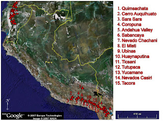
Cusco, and in the larger scale all of South America, is situated on the South American tectonic Plate.  The South American Plate has an interesting relationship with the surrounding plates.  The Cocos Plate and Nazca Plate (the remains of the Farallon Plate) are continually subducting under the western edge of the South American Plate.  It’s this subduction that is responsible for the lifting the Andes.  It is also the cause for the volcanos that are strewn throughout them.  Peru is known for having a shallow dip in subduction which would lead to less volcanic activity in Cusco.    

 You can see from the volcanic activity map that most volcanos are located in southern Peru.  The closest volcano to Cusco is Quimsachata, whose last explosion has been posited to be around 4450 b.c.e.  The interface of these tectonic plates along the Peruvian coast has caused many earthquakes in the past.  There are three recorded earthquakes for Cusco: January 30th 1943, May 21st 1950, and April 6th 1986.  The earthquake in May of 1950 had a magnitude of 7.0 and caused 1,625 deaths. 

Climate and Weather


Cusco has interesting weather due to its height (approximately 3,400 meters above sea level) and it’s closeness to the equator. There are two well defined seasons: a dry and rainy season. The dry season runs from May to October, and then a rainy season following from November to April. . Cusco has a subtropical highland climate. When it isn’t the rainy season, the climate is dry and temperate. The high temperature averages between 18 and 20 degrees Celsius, and the low temperature averages between zero and six degrees Celsius. The coolest months are June and July with a temperature of 0.4 degrees Celsius. Because of its interesting location and altitude, the wind patterns come in big masses from the southwest jungle, Plateau of Lake Titicaca and even Patagonia. There are also south jungle winds that provide humidity and are carried by the east winds as well. Rain is very common, of course, along with frost and hail. Snow is almost never seen. It was in June 1911 that the last snowfall was recorded. The climate at Machu Picchu has a more varied weather pattern. It can rain at any moment and have blue skies the next.